Difference between revisions of "Shadew River"
Trismegistus (talk | contribs) m |
Trismegistus (talk | contribs) m |
||
| Line 12: | Line 12: | ||
Channels of the mouth of the Shadew River, apart from the main channel, include the [[Little Shadew River]], the [[Umbarbifa River]], the [[Saint Ameldaib River]], the [[Alespetti River]], and the [[Andravish River]]. | Channels of the mouth of the Shadew River, apart from the main channel, include the [[Little Shadew River]], the [[Umbarbifa River]], the [[Saint Ameldaib River]], the [[Alespetti River]], and the [[Andravish River]]. | ||
| + | |||
| + | =Courses of the River= | ||
| + | The Shadew River may be divided very broadly into three courses, the upper course that originates from the [[Amandal Plateau]] and flows through [[Zangolia]], the middle course, that flows to the southeast, south of the [[Jashund Mountains]] and is the longest portion, and finally the lower course, that passes southeast of [[Thrace]], through the [[Canyon of the Shadew]], through the [[Shadmaus]], around [[Borenlas]], and into the isles of the [[Shadevan Delta]]. | ||
=Shadew River God= | =Shadew River God= | ||
Revision as of 05:51, 2 December 2019
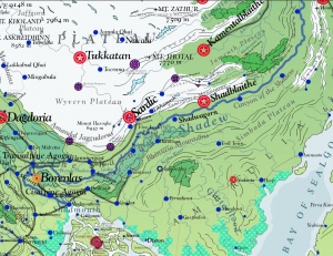
The mightiest river of northern Asdauria is surely the Shadew River. (pronunciation /~SHAY-juh/). Thousands of streamlets draining from the Jaggudorns flow into the Shadew River as it runs its turning course down to the sea, disemboguing into the Shadevan Delta which derives its name from the river. The water swells during the spring when the snows of the lower Jaggudorns melt and drain into the great river.

Magdeologic Past
Magdeologers believe that the Flood of Karuthaya over ten thousand years ago emptied an enormous body of water from the Vale of Shadew by means of the Shadew River. The power of this water carved the Canyon of the Shadew and shaped the islands of the Shadevan Delta.
Shadmouth
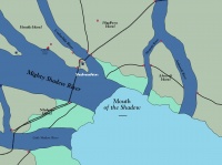
The mouth of the Shadew River is in the small region of Agogia known as the Shadmouth and leads into the Shadevan Delta. The width of the main channel of the Shadew River is 25800 feet wide (nearly five miles). The region is subject to the tectonic processes of the neighboring Jaggudorn Plate and the trench of the Pallathantic Sea and is generally very flat, near sea level in elevation with numerous small hills. The river around the Shadmouth is relatively shallow and this is thought to account for its very great breadth, in addition to its enormous discharge. The main city of the Shadmouth is Shadmouthton.
Channels of the mouth of the Shadew River, apart from the main channel, include the Little Shadew River, the Umbarbifa River, the Saint Ameldaib River, the Alespetti River, and the Andravish River.
Courses of the River
The Shadew River may be divided very broadly into three courses, the upper course that originates from the Amandal Plateau and flows through Zangolia, the middle course, that flows to the southeast, south of the Jashund Mountains and is the longest portion, and finally the lower course, that passes southeast of Thrace, through the Canyon of the Shadew, through the Shadmaus, around Borenlas, and into the isles of the Shadevan Delta.
Shadew River God
The Shadew is also the name of the numinous river divinity believed to inhabit it waters and watch over it. The ancient High Shadevan Tribes called the god of the Shadew River 'Shashagin.'
River Traffic
Despite several awesome waterfalls as it descends through the Bhinsasas, the Shadew River is a great concourse of barges and river vessels, communicating the Jaggudorn Plateau with the Pallathantic Sea thanks to the Grand Shadew Canal. Before the canal, river barges could not pass the fifth cataract, Brewde Shadew, near Auricetino. Conversely, river traffic from the Vale of Shadew had to stop before the first cataract, Balik Shadew, in Shaddago.
See Also
| This article is a stub. It requires further development by the creator. |
