Difference between revisions of "Buthyrian Channel"
Trismegistus (talk | contribs) (created) |
Trismegistus (talk | contribs) m |
||
| Line 1: | Line 1: | ||
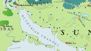
[[File:MapButhyrianChannel.jpg|thumb|300px|The Buthyrian Channel lies between [[Tangshan]] and [[Sungo]].]] | [[File:MapButhyrianChannel.jpg|thumb|300px|The Buthyrian Channel lies between [[Tangshan]] and [[Sungo]].]] | ||
| − | The long Buthyrian Channel lies between [[Sungo]] and [[Tangshan]] in a northwest to southeast direction. The Buthyrian Channel is the northernmost point in the [[Sungotine Sea]]. The southern bounds of the channel are defined by [[Bo Thak Zhu]] Island, [[Lwek Hsün]] Island, and [[Tsoh Liu]] Island. Its northwest end rests south of the great port city of [[Lwokshambai]], south of the western foothills of the [[Shwok Shanya Mountains]]. The port cities of [[Trah Zum]] and [[Mim Lo]] also lie along the coast of the Buthyrian Channel. For this reason, it is a much voyaged sea route, especially for commerce between Sungo and Tangshan. | + | The long Buthyrian Channel lies between [[Sungo]] and [[Tangshan]] in a northwest to southeast direction. The Buthyrian Channel is the northernmost point in the [[Sungotine Sea]]. The southern bounds of the channel are defined by [[Bo Thak Zhu]] Island, [[Lwek Hsün]] Island, and [[Tsoh Liu]] Island. Its northwest end rests south of the great port city of [[Lwokshambai]] in [[Shambai Jiak Harbor]], south of the western foothills of the [[Shwok Shanya Mountains]]. The port cities of [[Trah Zum]] and [[Mim Lo]] also lie along the coast of the Buthyrian Channel. For this reason, it is a much voyaged sea route, especially for commerce between Sungo and Tangshan. |
The waters of the Buthyrian Channel are often calm and the weather is usually warm to mildly warm with frequent rain storms in spring and late summer. | The waters of the Buthyrian Channel are often calm and the weather is usually warm to mildly warm with frequent rain storms in spring and late summer. | ||
Latest revision as of 07:50, 18 November 2014
The long Buthyrian Channel lies between Sungo and Tangshan in a northwest to southeast direction. The Buthyrian Channel is the northernmost point in the Sungotine Sea. The southern bounds of the channel are defined by Bo Thak Zhu Island, Lwek Hsün Island, and Tsoh Liu Island. Its northwest end rests south of the great port city of Lwokshambai in Shambai Jiak Harbor, south of the western foothills of the Shwok Shanya Mountains. The port cities of Trah Zum and Mim Lo also lie along the coast of the Buthyrian Channel. For this reason, it is a much voyaged sea route, especially for commerce between Sungo and Tangshan.
The waters of the Buthyrian Channel are often calm and the weather is usually warm to mildly warm with frequent rain storms in spring and late summer.
See Also
| This article is a stub. It requires further development by the creator. |
