Difference between revisions of "Corundy"
Trismegistus (talk | contribs) m (add image) |
Trismegistus (talk | contribs) m (fiddle with map size) |
||
| Line 1: | Line 1: | ||
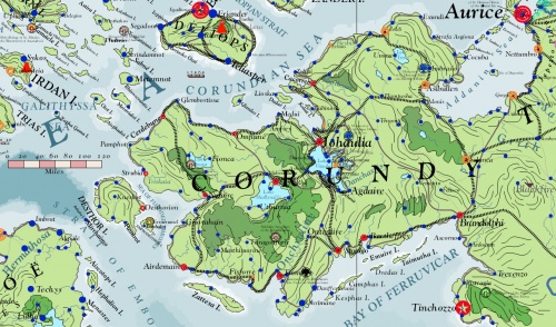
The name of the greatest peninsula of the eastern Pallathantic that stretches from the Asdaurian mainland, chiefly Throvy, westwards into the sea. The name derives from the Yophenthean word for córondë, 'king, ruler.' Corundy was one of the successor-kingdoms of the Yophenthean Empire. Corundy is a peninsula that juts from the western edge of Asdauria into the sea. To the north is the Pallathantic Sea and to the south is the Memnosian Sea. The account of [[Aturyanda]] or the [[Aturyandakumi]] reports that over twelve thousand years ago, King Aturyanda of antediluvian Kathyasundi escaped the ravages of the Great Flood with his followers in the highlands of what is modern Corundy. After the waters resided, he gathered survivors and formed the seeds of the [[Great Flood Survivor Cultures]] of [[Kalama]]. Millennia later, immigrating [[Midringir Tribes]] overtook the decaying Kalaman Civilization and built up [[Midretasso]] with its capital in Cetibrymio. During the centuries of the [[Midretassene Empire]], the myth of the hero [[Addan]] and of the numinous god [[Vimal]] became steeped in hearts of the people. This empire expanded and conquered the [[Ithatian Islands]] and what is now modern-day [[Dúrandwor]], but was in turn conquered by the [[Yophenthean Empire]]. | The name of the greatest peninsula of the eastern Pallathantic that stretches from the Asdaurian mainland, chiefly Throvy, westwards into the sea. The name derives from the Yophenthean word for córondë, 'king, ruler.' Corundy was one of the successor-kingdoms of the Yophenthean Empire. Corundy is a peninsula that juts from the western edge of Asdauria into the sea. To the north is the Pallathantic Sea and to the south is the Memnosian Sea. The account of [[Aturyanda]] or the [[Aturyandakumi]] reports that over twelve thousand years ago, King Aturyanda of antediluvian Kathyasundi escaped the ravages of the Great Flood with his followers in the highlands of what is modern Corundy. After the waters resided, he gathered survivors and formed the seeds of the [[Great Flood Survivor Cultures]] of [[Kalama]]. Millennia later, immigrating [[Midringir Tribes]] overtook the decaying Kalaman Civilization and built up [[Midretasso]] with its capital in Cetibrymio. During the centuries of the [[Midretassene Empire]], the myth of the hero [[Addan]] and of the numinous god [[Vimal]] became steeped in hearts of the people. This empire expanded and conquered the [[Ithatian Islands]] and what is now modern-day [[Dúrandwor]], but was in turn conquered by the [[Yophenthean Empire]]. | ||
| − | [[File:Corundy_2750_001.jpg|thumb| | + | [[File:Corundy_2750_001.jpg|thumb|500px|Map of Corundy]] |
=History= | =History= | ||
Revision as of 12:28, 5 January 2014
The name of the greatest peninsula of the eastern Pallathantic that stretches from the Asdaurian mainland, chiefly Throvy, westwards into the sea. The name derives from the Yophenthean word for córondë, 'king, ruler.' Corundy was one of the successor-kingdoms of the Yophenthean Empire. Corundy is a peninsula that juts from the western edge of Asdauria into the sea. To the north is the Pallathantic Sea and to the south is the Memnosian Sea. The account of Aturyanda or the Aturyandakumi reports that over twelve thousand years ago, King Aturyanda of antediluvian Kathyasundi escaped the ravages of the Great Flood with his followers in the highlands of what is modern Corundy. After the waters resided, he gathered survivors and formed the seeds of the Great Flood Survivor Cultures of Kalama. Millennia later, immigrating Midringir Tribes overtook the decaying Kalaman Civilization and built up Midretasso with its capital in Cetibrymio. During the centuries of the Midretassene Empire, the myth of the hero Addan and of the numinous god Vimal became steeped in hearts of the people. This empire expanded and conquered the Ithatian Islands and what is now modern-day Dúrandwor, but was in turn conquered by the Yophenthean Empire.
History
Corundy has a rich history of princes, heroes, and artistic treasures. Corundy is heir to the ancient civilization of Kalama, one of several Great Flood Survivor Cultures. The intervening Midretassene Civilization transmitted and transformed much of this ancient culture to modern-day Corundy. Modern Corundy is completely liberated from the former rule of the Gorcorumbese Empire and the Kalikán Empire. Eastern Corundy is subject to the Aurician Empire and the Republic of Johaulia is all that stands between Aurice and the other principalities of the peninsula. Aurice has refrained from gobbling up the princedoms of Corundy so as not to appear tyrannical like Gorcorumb and prefers to manipulate rulers and people behind the scenes. Johaulia is considered a puppet-state of Aurice and many Johaulians deeply resent statements to this effect.
Kalaman Period
Midretassene Period
Yophenthean Period
Corundian Period
Middle Ages of Chaos
Isbajutha
Gorcorumbese Dominion
City-States
Climate and Geography
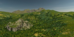
The climate of Corundy is warm, sometimes very warm in the summer until monsoons from the Memnosian Sea temper the heat in late summer. It is cool and rainy in the winter when cold storms of rain drift in from the north. Cypress trees, Stone Pines, olives, and vineyards dot the rural hills of Corundy. Corundian wines compete for prestige with those of Ithatia, Ebinóë, Throvy, and Glaye. Olive orchards produce oil shipped around the world. Riots of hills and small mountains flow from the south through the land to the north. Central Corundy is hilly plateau, held up by the Thugad and Damisatta Mountains. In this region sits Lake Vimala, the purview of the numinous god Vimal whose fame persists from Midretassene times. Cities and towns down the coasts of this deep lake that drains over great cataracts by the city of Johaulia into the Pallathantic Sea.
Politics
Johaulia
The Republic of Johaulia on the Tassan Highlands and in the valley of Vimal is widely seen as the most prestigious state in Corundy. Johaulia is regarded as the cultural guardian of Midretassene and Kalaman civilizations. The city of Johaulia is sometimes viewed as the art capital of the Pallathantic. The name Johaulia can be used interchangeably for the capital city or the entire state of the Republic of Johaulia.
Aurician Influence in Corundy
The two provinces of Zamir belong to the Aurician Empire. Aurice wields considerable influence among the states of Corundy due to its political size and economic influence. Aurice liberated Corundy from the Gorcorumbese Empire of the Ephysgæes as a consequence of the Fifth Geddamin War and gained much prestige in the peninsula. Aurice vowed to protect Corundy from encroachment of the Geddamin through the 27th century (2600's). The Empire of Magdala and the Republic of Ithatia has expressed discontent with Aurice's seeming economic domination of Corundy. Aurice uses its economic clout to benefit its trade in Corundy and to benefit Auricia corpora mercia. Ithatia sometimes calls for Aurice to respect the sovereignty of the city-states of Corundy. As Gorcorumb has continued its decline, the need for Aurician protection has become irrelevant in the eyes of some leaders.
The Republic of Johaulia in the Tassan Highlands holds much prestige and often functions in cooperation with Aurice in matters of foreign policy. This strengthens Aurice's hand and is seen by some as political compromise on the part of Johaulia. The Republic of Johaulia is widely viewed as an artistic haven and not well-founded for the nature of foreign policy. The Throvian language is related to the Tassan language giving some substance to a cultural tie.
Some Aurician magistrates have called for a unified Corundy, but are not agreed on how this could be accomplished.
Corundian Coast
The Corundian Coast is the western and southern portion of Corundy where the historic Corundian Language predominates and includes the city-states of Omflune, Estyo Rhe, Cerdebune, Strubia, Numire, Desthor, Airdemain, Tiomaire, Smiago, Bantheffrey, and Brandolphi. These city-states arose in the disorder that followed the collapse of the rule of Prince Ulcanov of the Shattered Waters. They became subject to the dominion of Medibgö and then the New Kalikán Empire in the 26th century (2500's). They are fiercely independent of each other and of Johaulia, but acknowledge Johaulia as a more neutral party than each other. Their citizens often label their rulers and magistrates as Pro-Aurician or Anti-Aurician, though in practice, few are purely either one.
Languages of Corundy
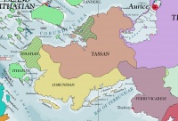
There are three groups of languages in Corundy. Ithatian is the oldest and has been spoken in Corundy the longest. Corundian Ithatian is a different dialect from insular Ithatian. The Tassan and Languages are descended from the ancient Midretassene Language. Corundian comes from the language of the Yophenthean conquerors. Ferruvicarese is related to ancient Thybidite and thus distantly related to Midretassene. Tassan and Throvian share some mutual intelligibility, but Tassans are staunchly proud of their language and culture and Tassan vies with Throvian as the language of diplomacy for the peninsula. Auricians have been careful to employ ambassadors and diplomats who speak fluent Tassan so as to avoid any appearance of denigrating the sovereignty of the Johaulian Republic. Tassan is the language of choice for operas throughout Corundy and the Pallathantic Sea.
Economy
Corundy is well-placed for trade and commerce. Despite its rolling hills that may dampen land transport, its many vibrant sea ports have commerce with the nations of the Pallathantic-Memnosian Seas. Corundy is seated along with Throvy on the western end of the lucrative caravan routes through Asdauria to Sungo and elsewhere in the far east. The map of trade routes shown here uses blue for sea are river routes and red for land routes. Sky routes are reserved for light cargo with high commercial value as sky vessels, even modern titancraft air vessels, do not have the capacity to warrant their cost. The map shows the central importance of Corundy in Pallathantic Trade with the far east and Zephasia to the south.
Flags of Corundy
Noble Republic of Aurice
The provinces of Zamiria are subject to Aurice. Throvian is spoken widely in the coast towns and cities while Tassan is spoken in the hills and plateau.
Republic of Johaulia
The four-petaled golden flower of Johaulia rests on a berry-colored field and represents the aspirations of the Tassan people of Johaulia.
See Also
| This article is a stub. It requires further development by the creator. |


