Mathgefrew Mountains
Revision as of 12:49, 20 September 2015 by Trismegistus (talk | contribs) (Created page with "The Mathgefrew Mountain Range of southern Pytharnia separate the coastal land of Dúrandwor from High Pytharnia to the north. The range lies roughly east to west...")
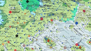
The Mathgefrew Mountain Range of southern Pytharnia separate the coastal land of Dúrandwor from High Pytharnia to the north. The range lies roughly east to west and marks the magdeological separation between the southern half of the imputed Pytharniaca Plate and the northern half. Magdeologers believe the mountains are older than the Jaggudorns due to their gentle sloping and well worn condition. The highest elevation is about 13 DF (2100 meters or 6900 feet). They have historically been the political and cultural division between Dúrandwor and High Pytharnia. The Mathgefrews are home to some scenic forests
See Also
| This article is a stub. It requires further development by the creator. |

The Mathgefrew Mountains of southern Pytharnia