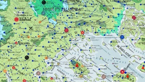
Mathgefrew Mountains

The Mathgefrew Mountain Range of southern Pytharnia separate the coastal land of Dúrandwor from High Pytharnia to the north. The range lies roughly east to west and marks the magdeological separation between the southern half of the imputed Pytharniaca Plate and the northern half. Magdeologers believe the mountains are older than the Jaggudorn Mountains and the Ithrad Mountains due to their gentle sloping and well worn condition. The highest elevation is about 13 DF (2100 meters or 6900 feet) above sea level. They have historically been the political and cultural division between Dúrandwor and High Pytharnia. The Mathgefrews are home to some scenic woodlands, including the famous Vaskopir Forest. Moving from east to west, the East Mathgefrew Mountains of the range start south of the Nystasy River, south of the Pytharnee Dromb Mountains, continue west along the northern frontier of Thrain and Ogentir where they become the Western Mathgefrew Mountains, then turn to the south, through eastern Gonfaloy. One of the range's highest peaks is Mount Astranf which is 12.85 DF(2069 meters or 6788 feet) above sea level.
Orographic rainfall and sometimes snow are generated on the north and south slopes of the Mathgefrew Mountains, though it is more frequent in Dúrandwor in the spring and summer.
The Mathgefrew Mountains have served in the past as a refuge for religious and ethnic groups. The Arathracian Sanctuary of Oiglic rests in the Eastern Mathgefrew Mountains as an autonomous entity. The Incarnandist Refuge of Holy Enlightenment rests in roughly the middle of the range. The halfling city of Gacksplad rests west of Mount Astranf.
Resources
The West Mathgefrew Mountains are rich in iron deposits.
See Also
| This article is a stub. It requires further development by the creator. |