Search results
Jump to navigation
Jump to search
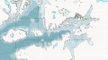
File:MapLocatorThykomia.jpg Locator Map of the Thykomian Islands(1,477 × 821 (266 KB)) - 12:28, 8 January 2014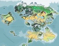
File:Asdarah WorldIsland+Orrhymby 2750 001.jpg Screen Capture of Asdarah Map, showing World-Island, Orrhymby, and adjacent islands.(1,010 × 803 (265 KB)) - 18:58, 27 October 2013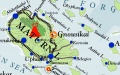
File:Maturn&NeighboringIslands 2750 001.jpg Screen Capture of Maturn and neighboring islands to the east from Asdarah Map, 2750.(1,308 × 817 (242 KB)) - 18:13, 27 October 2013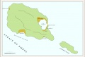
File:BalijahuCities 2740 001.jpg Screen Capture from local map, Islands of Balijahu and Aliskemnot, 2740, showing urban areas(1,153 × 776 (144 KB)) - 14:00, 10 November 2013
File:MapLocatorShadevanDelta.jpg Locator Map of Shadevan Delta Islands in the Greater Pallathantic(1,476 × 822 (261 KB)) - 12:26, 8 January 2014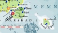
File:MapNarshadGehemerBarseBarra.jpg Map of Narshad and neighboring Islands(1,382 × 797 (177 KB)) - 20:15, 27 December 2013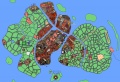
File:AuriceCity Overview 2750 WIP 001.jpg Screen Capture of Islands of City of Aurice from Aurice City Map, ca 2750.(1,183 × 808 (436 KB)) - 18:35, 27 October 2013


