Weshif

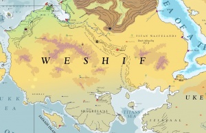
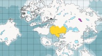
The great desert of southwestern Asdauria is called Weshif, the name used by the Thammazite Tribes and their predecessors for millennia. Weshif is bounded by the the Jukk Sea to the southwest, the Strait of Ummak to the west that separates it from Danona, the Memnosian Sea to the northwest, the Adamantine Mountains to the north, the Sea of a Thousand Curses to the east, and the Titans Sea to the south. The land of Shagrela'al, also to the south, is not considered part of the Weshif Desert. Weshif is joined by a neck of land to Ukelia.
Weshif is one of the great deserts of the world of Asdar and for this reason is sparsely inhabited with life. Camel caravans are often the only sight on the horizons of the Weshif Desert. Historically, Weshif is important to the Thammazite Tribes and other desert tribes that migrated over it in search of green pastures. The Imzaha religion is the most widespread throughout the region.
Asdarography
Weshif is almost entirely bounded by bodies of water or great mountains. The Memnosian Sea forms the northwestern bound of the region. The Adamantine Mountains form its northern natural boundary, reaching between the end of the northern tongue of the Sea of a Thousand Curses almost nearly to the Memnosian Sea. The Strait of Ummak which reaches between the Memnosian Sea and the Sea of Malankhas separates Weshif from Danona. The Sea of Malankhas and the Titans Sea form the southern bounds of the region, the Titans Sea separating Weshif from much of Ukelia and all of the Sahimb. Only two tongues of land join Weshif to the rest of the world. Yephalah which passes between the Adamantine Mountains and the Memnosian Sea joins northern Weshif with greater Asdauria, south of Corundy, and the land of Dhaalizoond joins southeastern Weshif with Ukelia in Disradún
The Zakhomite Mountains separate the dry interior from the green belt of Orthont in northern Weshif. Lower Shelekhumbia is similarly green and also separated from the desert south by small mountains. The Leh-Shelekhumbis River is by far the largest river in Weshif and drains the rain and snowfall of the Adamantine Mountains through the land of its namesake, Shelekhumbia which is part of the Sultanate of Beph-Themesh.
The Luphkhaymen Mountains runs from north to south through Weshif, leaving over half to the west and less than half the surface area of Weshif to the east. In the mid stretch of these mountains, the chain forks into two tongues which wrap the broad Valley of the Djinn. The discontinuous tongue of mountains is called the 'Eleph Sahida Mountains.
The western interior of the region is dominated by the Dashiluk Plateau, an extensive, rocky outcropping which with its numerous hillocks, canyons, and caves, has served as a refuge for desert tribes. The three much smaller, physically separate plateaus of the region are the Zahrab Plateau, the Jeher S'uryam Plateau, and the Iyamuth' Plateau. Important oasis settlements of the western interior include Sa'ali-Numphat, Anshiwaz, and Shaggath Nissur.
The eastern interior of Weshif is a lawless desert. Memorable features of the region include the Leykumdha Oasis, the Dome of Qafzibo, the Jiji Plateau, the Qasumir Plateau, and Wadi Atamaru which drains seasonally into the Sea of a Thousand Curses. The lowest point in Weshif is in this region in Darfs Adina Erg rests at 1.65 DF or 207.4 gnödva (265.5 meters or 871 feet) below sea level.
The southernmost reaches of Weshif blend into the Shagrela'al Peninsula. These lands along the coast and the edge of the peninsula and Weshif are semi-arid, having some drought-resistant vegetation and hardy animals that can endure the climate. These include the lands of Behrat and Dhaaz.
Creatures
Some of the more unusual creatures of Weshif include the white Pegasi Mounts of the Royal Knights of Shagrela'al and the Devil's Well, a creature of extraordinary trickery found in deserts and semi-arid lands of Disradún and Weshif. Lying in the sand with its great body covered, the devil’s well presents itself as a delicious pool of cool water at the bottom of a narrow, cone-shaped hole in the sand. It uses this ploy to attract a victim which it devours.
Communications
Sea vessels are the most common form of transportation between points located on the coastal exterior of the region. Only Beph-Themesh and Azzabboon have dragonrail service out of all Weshif. Transportation through the interior requires camel caravan or skycraft. Eastern Weshif is prone to brigandage so much so that nearly all transportation between Dhaalizoond and western Weshif is handled by sea barges in the Titans Sea. Skycraft must needs avoid the Dominion of the Djinn where overflights are unwelcome and vigorously deterred. Titanships typically fly over the western portion or through the Strait of Ummak along Weshif's western coast.
States of Weshif
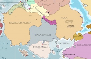
Beph-Themesh is the most populous state and controls the rich Leh-Shelekhumbis River as it flows out of the Adamantine Mountains. The Kingdom of Orthont is the next most populous. The Kingdom of Shaliz-um-Warif makes up nearly half of western Weshif. The Kingdom of Rala-Pithur rests in south central Weshif. The neck of land that joins Weshif to Ukelia is controlled by Dhaalizoond (Thelisond) and the Knights of the Seven Seals. Eastern Weshif and the coast of the Sea of a Thousand Curses is a place of anarchy, thought to be the domain of desert thieves, djinn, and haunted ruins sunken under the dunes where legend says the Titans once ruled the world. The Titan Wastelands is part of this region and lacks any central government. However, along the western shore of the Sea of a Thousand Curses are found several autonomous merchant ports which must defend themselves from inland bandit raids. These cities include Adhiruz, Ezgush, and Faad Ehrun. These cities are part of a greater commercial network and enable waterborne transportation between the far East, including Sungo, and the West, principally by means of the Sea of a Thousand Curses. The Kingdom of Shagrela'al rests in southernmost Weshif and is the core territory of the Imzaha religion. Shagrela'al is thought be historians to be the homeland of the ancient Thammazite Tribes. The large island Kingdom of Safaadi, to the west of Shagrela'al in the Sea of Malankhas, is culturally considered part of Weshif.
See Also
| Antarctica | Asdauria | Barathorn and Orrhymby | Danona | Pallathantic Sea | Pytharnia | Sungo | Two Bahunas |
|---|---|---|---|---|---|---|---|
|
Deepearth
|
|
Major Isles
Major Isles Minor Isles |
Deepearth |


