Aurician Empire
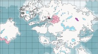
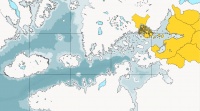
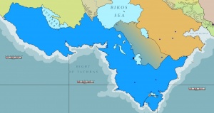
![]() The Aurician Empire consists of the Imperial City of Aurice, island and land holdings of Asdauria, the Shadevan and Agogian Provinces, and overseas possessions, especially Skaligdæ and Bijälenland. The Noble Republic of Aurice and the Empire of Magdala jointly appointed the rulers of the Viceroyalty of Jagohr until the end of the Sewdhaine War. Aurician commercial and legal interests control the very lucrative Grand Shadew Canal.
The Aurician Empire consists of the Imperial City of Aurice, island and land holdings of Asdauria, the Shadevan and Agogian Provinces, and overseas possessions, especially Skaligdæ and Bijälenland. The Noble Republic of Aurice and the Empire of Magdala jointly appointed the rulers of the Viceroyalty of Jagohr until the end of the Sewdhaine War. Aurician commercial and legal interests control the very lucrative Grand Shadew Canal.
The empire is divided into Over-Provinces and Provinces. The Over-Provinces are Lucacia, Corundy, Asdauria, Thykomia, Shadevan Provinces, Agogia, Bijälenland, and Skaligdæ. These are divided into Provinces some of which exercise local government in the form of a parliament of hereditary members, and others elected. Each Province may be divided into Prefects, Municipia, or Counties, sometimes a combination of these.
There are also several client states which are dependent upon the Empire and often work closely with the overall military strategy of the empire.
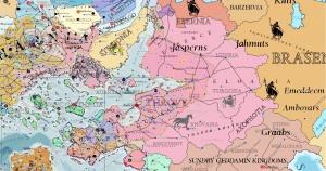
Imperial Provinces and Colonies
Lucacia (Free Parliaments)
- Goscundy, includes islands of Addanine Sea known informerly as 'Taglondio'.
- Ugornia
- Uthracunia
- Frantigoria
- Alascundy
- Upper Ibrew
- Brodora (was "Brawthorn")
- Lelegundy
Corundy (Semi-Free Parliaments)
Zamir is a mountain region of northeastern Corundy. Most Zamirites speak a dialect of Tassan, but Lucacian speakers make up the majority of the inhabitants along the coast. For political and strategic reasons due to the Fourth Geddamin War, Zamir became subject to the Aurician Empire. The land was divided into two parts for administrative purposes. The language of Zamir (or Zamiria) is Tassan which is closely related to the Lucacian Language. There are some cultural ties between Zamir and Lucacia and both lands were formerly part of the Midretassene Empire in addition to the fact that their current spoken languages descended from the Medregan Language Family.
Near Eloaria (Subject Parliaments)
Far Eloaria (Military Governors)
Thykomia (Subject Parliament)
Shadevan Provinces (Subject Parliaments)
- (Incomplete list of islands
- Adámphë Island, Eronti Island, Threbcain Island, Tionant Island, Thisgrundi Island, Zeth Baire Island, Yairuny Island, Ambrundi Island, Iailcumb Island, Engeodris Island, Timbraduel Island, Griainsundi Island, Musimoria Island, Sekuph Island, Trefrensel Island, Essebune Island, Karkagunot Island, Kaibune Island, Yamish Island, Dradak Island, Pacumethel Island, Pembélikë Isle, Paiolion Island, Baspenot Island, Xyathoth Island, Strentor Island, Isiagos Island, Sampha Island, Psaronot Island, Kumeikenot Island, Stroultë Island)
Agogia (Subject Parliaments)
Bijälenland (Imperial Governors)
Skalgigdæ (Imperial Governors)
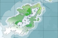
The huge island of Skaligdæ is considered part of the Antarctic Plate and is divided into numerous municipia or townships. It is very cold in the winter, except for the northernmost coast which is cool to cold in the winter. This rugged land offers great resources for Corpora Mercia of the Empire and vast challenges to hardy colonists. It is sometimes the place of exile for criminals and those whose political fortunes have plummeted.
Garskolya
In the New World to the west of the Dragonreaches lies the Aurician colonial city of Garskolya.
Buffer and Client States
Reputed Buffer and Puppet States These lands are in principle independent, but in practice are dependent upon the foreign policies of the Aurician Empire.
- March of Pastravia, annexed in 2751, given full representational powers
- Skarpatha
- Vice-Royalty of Jagohr jointly administered by Aurice and Magdala
- Republic of Johaulia and the West Corundian Principalities
- Duchy of Ferruvicar
- Streionia
Shaddago (see Joint Enterprise Zone)
Hostile Neighbors Ebernia (Bisontaurs) Igdiria (Bisontaurs) Turgosia (Centaurs) Streionia (Ambrulia) (Centaurs)
Sources
 Primary Sources
- Acts of the Senate of the Grand Duchy of Aurice, up to 2625
- Acts of the Senate of the Republic of Aurice, 2625 to present
 Secondary Sources
- Aurician Colonial Policy from Grand Duchy to Republic, Barias ennekhá Perevath, 2653
- Corundy and the Fifth Geddamin War (Book), Rhionantis the Elder of Aurice, 2611
See Also
- Aurice
- Aurician Metropolis
- Aurician Parliamentary Reforms and Expansion of Suffrage
- Expansion of Inland Aurician Empire in Late 2600's
- Government of Aurice
- Noble Republic of Aurice
- Over-Province
| This article is a stub. It requires further development by the creator. |
