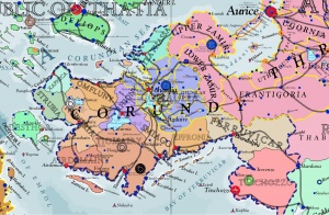
List of the States of Corundy
Revision as of 03:19, 11 November 2014 by Trismegistus (talk | contribs)
The political map of Corundy is divided among several governments. Since liberation from the Gorcorumbese Empire in 2587, Corundy is subject to a hodgepodge of rulers. The name 'Corundy' is somewhat contentious as it implies only the western portion of the peninsula in some contexts. The two provinces of Zamir, if considered together, comprise the largest division in surface area. Otherwise, the Republic of Johaulia is the greatest in area. Next are the Archpatriarchy of Tiomairy and the Archpatriarchy of Numiria.
| Name of State or Aurician Province | Capital | Year Established | Principle Culture | Estimated Population (ca 2750) | Remark |
|---|---|---|---|---|---|
| Archpatriarchy of Airdemainy | Airdemain | 2587 | Corundian | ||
| Archpatriarchy of Numiria | Numire | 2587 | Corundian | ||
| Archpatriarchy of Tiomairy | Tiomaire | 2587 | Corundian | ||
| Duchy of Barraine | Cerdebune | 2671 | Ithatian | 2586, liberated from GE, 2671, becomes independent | |
| Duchy of Desthor | Desthorion | 2671 | Ithatian | 2612, leaves Gorcorumbese Empire and joins Republic of Ithatia, 2671, becomes independent | |
| Duchy of Ferruvicar | Brandolphi | 2587 | Ferruvicarese | ||
| Duchy of Zavie | Cacorreo | 2587 | Jathya-Dhumi | ||
| Free Republic of Rhiony | Estyo Rhe | 2587 | Jathya-Dhumi | ||
| Principality of Effronia | Bantheffrey | 2587 | Corundian | ||
| Principality of Smiago | Smiago | 2587 | Corundian | ||
| Province of Lower Zamir | Zeddi | Tassan | Aurician Over-Province of Corundy | ||
| Province of Upper Zamir | Asdrallen | Tassan | Aurician Over-Province of Corundy | ||
| Republic of Dauneia | Cacorreo | 2671 | Ithatian | 2586, liberated from GE, 2671, becomes independent | |
| Republic of Johaulia | City of Johaulia | 2587 | Jathya-Dhumi | ||
| Republic of Strubia | Strubia | 2671 | IIthatian | 2586, liberated from GE, 2671, becomes independent |
Flags of Corundian States
Noble Republic of Aurice (Two Zamirias)


