Difference between revisions of "Jamenth"
Trismegistus (talk | contribs) m |
Trismegistus (talk | contribs) m |
||
| Line 2: | Line 2: | ||
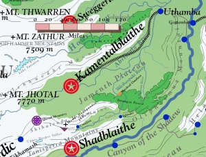
[[File:MapJamenth.jpg|thumb|300px|Jamenth is a great high mountain valley in southeastern [[Jaggudorns]].]] | [[File:MapJamenth.jpg|thumb|300px|Jamenth is a great high mountain valley in southeastern [[Jaggudorns]].]] | ||
| + | |||
| + | Jamenth become independent from the [[New Kalikán Empire|Thracian Empire]] in 2576 through the [[Reduction of Thrace]]. | ||
| + | |||
=See Also= | =See Also= | ||
Revision as of 21:07, 17 March 2018
Jamenth is a country in the southeastern high valleys of the Jaggudorns and was historically part of the New Kalikán Empire. The Valley of Jamenth comprises the Jamenth Plateau. Meltwater of the Jaggudorns creates three major rivers in Jamenth, the Abristalo River, the Skleihaspuki River, and the Igumit River which flow into the Shadew River. The Commonwealth of Jamenth comprises Jamenth and the Dospor Valley through which the Skleihaspuki River flows. Jamenth is walled to the north by the Helebhuodhi Mountains, to the south by the Shihalenda Mountains and the Tanisperra Mountains and the Olipheimuz Mountains. The largest forest in Jamenth is the Straugza Forest. The capital of the commonwealth is Kamentalblaithe. Jamenth borders Gantvia to the north, Shaddago to the south, Amandalia and Sardeichs to the west, and Hamalan to the east.

Jamenth become independent from the Thracian Empire in 2576 through the Reduction of Thrace.
See Also
| This article is a stub. It requires further development by the creator. |