Search results
Jump to navigation
Jump to search
Page title matches
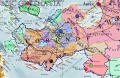
- [[File:MapPoliticalCorundy2745.jpg|thumb|300px|States of Corundy in 2745]] ...rea. Next are the [[Archpatriarchy of Tiomairy]] and the [[Archpatriarchy of Numiria]].4 KB (447 words) - 11:58, 23 January 2022
- #REDIRECT [[List of the States of Corundy]]43 bytes (7 words) - 20:20, 5 June 2014
Page text matches
- ...s. [[Babirrhoksha]], the capital of the Free Republic, rests on the shores of [[Lake Shallynaffe]]. =Chronology of Rhiony=1 KB (143 words) - 12:02, 23 January 2022
- [[File:MapLeagueofCorundy.jpg|thumb|300px|League of Corundy in 2749]] ...the two Zamirias. The league was inspired by the [[Dwarven Customs Union of the Jaggudorns]] and desired greater defense against the newly powerful [[A2 KB (306 words) - 09:40, 24 January 2022
- ...]] to the west, the [[Republic of Johaulia]] to the north, and the [[Duchy of Ferruvicar]] to the east. Effronia's economy relies upon fishing, shipping, ...nia_Locator.png|thumb|100px|Effronia is the purple area on this map. World of Asdar Map Screen Capture. ©2023 Kraig Hausmann, All Rights Reserved.]]1 KB (211 words) - 16:37, 29 December 2023
- ...|thumb|300px|Map of the Island of Desthor, the largest island in the Duchy of Desthor ]] ...a member of the [[Commonwealth of Arathracian States]] and the [[League of Corundy]].1 KB (209 words) - 14:05, 23 September 2017
- [[File:MapCorundyCulturalRegions.jpg|thumb|300px|The Thuvaki Coasts of [[Corundy]] were settled by ancient [[Ithatia]]ns.]] ...e commemorated in celebrations and private practices. The Thuvaki dialects of [[Ithatian Language|Ithatian]] are spoken there.792 bytes (105 words) - 20:38, 19 January 2024
- ...[Corundian Language]]. It is a member of the [[Commonwealth of Arathracian States]]. The demonym is Smiagonese. Smiago rests on the southern coast of Corundy, opening to a narrow bay called the [[Smiagonese Bay]].810 bytes (116 words) - 01:42, 1 January 2019
File:MapPoliticalCorundy2745.jpg States of Corundy, 2745; Asdarah Map Screen Capture; All Rights Reserved(1,254 × 818 (532 KB)) - 21:21, 25 December 2021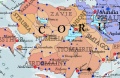
File:StatesofWesternCorundy2745.jpg Screen Capture from Asdarah Map, States of Western Corundy in 2745, All Rights Reserved(1,252 × 816 (434 KB)) - 01:44, 6 May 2014- [[File:MapPoliticalSmiago.jpg|thumb|300px|Smiago rests in middle southern [[Corundy]].]] ...rity of [[Rhiony|Rhionian]] citizens whose religion is based upon the cult of [[Rhio]] mixed with practices inherited from ancient [[Kalama]]. The ethni2 KB (353 words) - 02:55, 16 June 2022
- #REDIRECT [[List of the States of Corundy]]43 bytes (7 words) - 20:20, 5 June 2014
- Omfluny is a duchy of northern [[Corundy]] that is known for its blend of [[Thuvaki]], [[Arathracian]], and [[Jathya-Dhumi]] cultures. It is predomi ...times, to remain a sovereign state. There are several movements for parts of Omfluny to become independent or to unite with their neighbors.1 KB (213 words) - 10:27, 24 January 2022
- ...], [[Lioska]], and [[Ermos]]. The island of [[Dadaë Island|Dadaë]] is part of Tlathassa. ...largest rivers are the [[Murthmur River|Murthmur]] which flows to the port of Laxiapoion and the [[Besbis River|Besbis]] on the border with [[Aurician Em3 KB (437 words) - 17:32, 31 December 2021
- ...e Corundian Sea rests between the peninsula of [[Corundy]] and the islands of [[Deliops]] and [[Zander]].]] ...the greater Pallathantic Sea. The waters are temperate and generally free of choppy weather. [[Teliasper]], [[Omflune]], [[Laxiapoion]], and [[Cetibrym723 bytes (101 words) - 00:29, 20 December 2021
- ...Tiomairy.jpg|thumb|300px|The Archduchy of Tiomairy rests in southwestern [[Corundy]].]] ...]] are also found within Tiomairy as well as the [[Arathracian Sanctuary]] of [[Erahusa]].3 KB (365 words) - 20:17, 1 January 2015
- ....jpg|thumb|300px|Map of the Island of Emprodesthor southeast of the island of [[Desthor]]]] ...ke of Desthor]]. Emprodesthor is the second largest island in the [[Duchy of Desthor]].2 KB (245 words) - 14:13, 23 September 2017
- ...age]], is spoken in southern and western Corundy. It is also the namesake of the Corundian Peninsula. [[File:MapLanguagesCorundy.jpg|thumb|300px|Languages of Corundy]]2 KB (247 words) - 10:42, 2 July 2022
- ...of the [[Fifth Geddamin War]] and foreshadowed the successive dismantling of the [[Gorcorumbese Empire]]. ...ependence of Corundy, except Desthor. Vimalia, Rhiony, and various coastal states were acknowledged as independent.692 bytes (92 words) - 02:01, 13 June 2022
- ...s one of three Arathracian ecclesiastical principalities in southwestern [[Corundy]].]] ...2586, the ecclesiastical archpatriarchy has existed since the restoration of Arathracian clergy after the [[Isbajutha]] and the country has been histori3 KB (425 words) - 20:18, 1 January 2015
- ....jpg|thumb|300px|The Archpatriarchy of Numiria lies on the west coast of [[Corundy]].]] ...Yoradha was once the seat of the [[Gorcorumb]]ese Governor of the satrapy of [[Kurundiya]].2 KB (354 words) - 21:10, 25 December 2021
- [[File:MapPoliticalCorundy2745.jpg|thumb|300px|States of Corundy in 2745]] ...rea. Next are the [[Archpatriarchy of Tiomairy]] and the [[Archpatriarchy of Numiria]].4 KB (447 words) - 11:58, 23 January 2022

