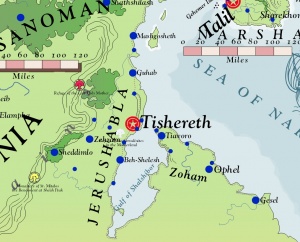
Jerushabla

Jerushabla is the homeland of the Khahonri Tribes, including the Shaphrizite Tribe. Jerushabla is part of Thyria and was settled in the fourth millennium before Salmakhamer by Thammazite Tribesmen from Weshif. Jerushabla rests on a strip of land on the western shores of the Memnosian Sea on the continent of Danona. Jerushabla was ruled in ancient times by kings, including the renown sorcerer-king, Selukyal. Incarnandist Monotheism originated in Jerushabla in the eighth century, followed by the Isbajutha in the twenty third century. Jerushabla holds a long history and rich cultural contribution to the west. The modern capital remains Tishereth, the historical capital during the ancient Khahonri Kings. The language spoken is Khahonri.
Jerushabla is bounded on the north by Sanoman and the Gorcorumbese Empire, namely the eparchies that form historic Khesheph. The western end of the Massady Geth Mountains forms the western border of the country. To the south is the Plateau of Midiantir and the great desert wastelands of central Danona. The capital, Tishereth, rests within ten miles of the Memnosian coast.
The climate of Jerushabla is a warm Pallathantic climate, changing gradually as one moves south to a semi-arid desert climate.
In 2684, Jerushabla and Zoham were liberated from the Gorcorumbese Empire and became a self-governing republic. Zoham is a peninsula of land across the Gulf of Shalshibor and historically part of Jerushabla. The country has important trade relations with Narshad and other trade cities of the Memnosian Sea.
See Also
- History of Jerushabla
- Incarnandism
- Liberation of Jerushabla and Narshad (2684)
- List of the Rulers of Jerushabla
- Thyria
- Tishereth
| This article is a stub. It requires further development by the creator. |