Difference between revisions of "High Pytharnia"
Trismegistus (talk | contribs) m |
Trismegistus (talk | contribs) m |
||
| Line 1: | Line 1: | ||
| − | [[File: | + | [[File:MapHighPytharnia.jpg|thumb|300px|Outline of High Pytharnia]] |
| − | The name of the highlands lying between [[Lake Kasgo]] and the [[Ithrad Mountains]], and between the [[Massady Geth Mountains]] and the [[Great Disdrire Forest]], High Pytharnia was originally called simply Pytharnia from the word 'pytharn,' a drivation of the dwarven word 'Bu-than-ra,' a race of dragon now thought extinct. The name 'Pytharnia' gradually became applied to the entire subcontinent, so the name 'High Pytharnia' was adopted to distinguish the plateau from the greater denomination. | + | The name of the highlands lying between [[Lake Kasgo]] and the [[Ithrad Mountains]], and between the [[Massady Geth Mountains]] and the [[Great Disdrire Forest]], High Pytharnia was originally called simply Pytharnia from the word 'pytharn,' a drivation of the dwarven word 'Bu-than-ra,' a race of dragon now thought extinct. The name 'Pytharnia' gradually became applied to the entire subcontinent, so the name 'High Pytharnia' was adopted to distinguish the plateau from the greater denomination. High Pytharnia comprises the [[Magdalanate]], [[Warlock Hills]], [[Pytharnee Dromb Mountains]], [[Marshes of Baihu]], Southern [[Skelkast Forest]], the [[Ithrads]], the [[Amosgire]], and the valleys of the [[Hyndurnuse River|Hyndurnuse]] and the [[Nystasy River|Nystasy]]. [[Durrhaunve]] and [[Dúrandwor]] are not part of High Pytharnia. |
| − | High Pytharnia is the core territory of the [[Empire of Magdala]] and is divided into numerous principalities subject to the [[Emperor of Magdala]]. The great capital city of [[Trevirs]], as well as the cities of [[Giffadain]], [[Royal Trevirs]], and [[Tresper]] rest within High Pytharnia. High Pytharnia is well-cultivated and the farmlands and manors grow crops of wheat, barley, rye, flax, grapes, hay (alfalfa, clover), pulses, fruit trees, and sundry vegetables. Livestock include cattle, sheep, goats, chickens, ducks, swine, horses, and donkeys. | + | In ancient times, before the immigration of the [[Moigthe]], High Pytharnia included the core territory of the late [[God-King]] of the [[Neptultchi civilization]]. Stone monuments and ruins persist today, particularly north of [[Giffadain]] on the peninsula that juts into [[Lake Kasgo]]. The term the [[Magdalanate]] is used to specify the lands lying between [[Lake Kasgo]] and [[Lake Thrundgally]] which is only the eastern portion of High Pytharnia. |
| + | |||
| + | [[File:GustaveDoré+LandscapeinScotland+1878+PublicDomain.jpg|thumb|300px|High Pytharnia Hills.]] | ||
| + | |||
| + | High Pytharnia includes the core territory of the [[Empire of Magdala]] and is divided into numerous principalities subject to the [[Emperor of Magdala]]. The great capital city of [[Trevirs]], as well as the cities of [[Giffadain]], [[Royal Trevirs]], and [[Tresper]] rest within High Pytharnia. High Pytharnia is well-cultivated and the farmlands and manors grow crops of wheat, barley, rye, flax, grapes, hay (alfalfa, clover), pulses, fruit trees, and sundry vegetables. Livestock include cattle, sheep, goats, chickens, ducks, swine, horses, and donkeys. | ||
=Humanlikes of High Pytharnia= | =Humanlikes of High Pytharnia= | ||
Revision as of 23:05, 2 May 2016
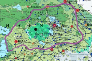
The name of the highlands lying between Lake Kasgo and the Ithrad Mountains, and between the Massady Geth Mountains and the Great Disdrire Forest, High Pytharnia was originally called simply Pytharnia from the word 'pytharn,' a drivation of the dwarven word 'Bu-than-ra,' a race of dragon now thought extinct. The name 'Pytharnia' gradually became applied to the entire subcontinent, so the name 'High Pytharnia' was adopted to distinguish the plateau from the greater denomination. High Pytharnia comprises the Magdalanate, Warlock Hills, Pytharnee Dromb Mountains, Marshes of Baihu, Southern Skelkast Forest, the Ithrads, the Amosgire, and the valleys of the Hyndurnuse and the Nystasy. Durrhaunve and Dúrandwor are not part of High Pytharnia.
In ancient times, before the immigration of the Moigthe, High Pytharnia included the core territory of the late God-King of the Neptultchi civilization. Stone monuments and ruins persist today, particularly north of Giffadain on the peninsula that juts into Lake Kasgo. The term the Magdalanate is used to specify the lands lying between Lake Kasgo and Lake Thrundgally which is only the eastern portion of High Pytharnia.
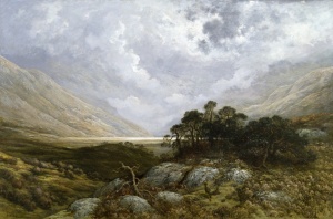
High Pytharnia includes the core territory of the Empire of Magdala and is divided into numerous principalities subject to the Emperor of Magdala. The great capital city of Trevirs, as well as the cities of Giffadain, Royal Trevirs, and Tresper rest within High Pytharnia. High Pytharnia is well-cultivated and the farmlands and manors grow crops of wheat, barley, rye, flax, grapes, hay (alfalfa, clover), pulses, fruit trees, and sundry vegetables. Livestock include cattle, sheep, goats, chickens, ducks, swine, horses, and donkeys.
Humanlikes of High Pytharnia
Humans are the most populous inhabitants of High Pytharnia. Uryala Gnomes and Halflings hold important enclaves. Lizardmen are well-established in the Marshes of Baihu. Dwarves are a significant humanlike minority in the cities.
See Also
| This article is a stub. It requires further development by the creator. |

