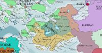
Corundy
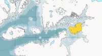
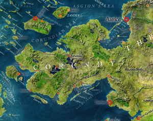
The name of the greatest peninsula of the eastern Pallathantic that stretches from the Asdaurian mainland, chiefly Throvy, westwards into the sea. The name derives from the Yophenthean word for córondë, 'king, ruler.' Corundy was one of the successor-kingdoms of the Yophenthean Empire. Corundy has a rich history of princes, heroes, and artistic treasures. Corundy is heir to the ancient civilization of Kalama, one of several Great Flood Survivor Cultures and several other civilizations. The intervening Midretassene Civilization transmitted and transformed much of this ancient culture to modern-day Corundy. Prior to Yophenthean settlement of the peninsula, the land was named Midretasso and, before that, Kshandiguh which means land of the golden bull.
Modern Corundy is completely liberated from the former rule of the Gorcorumbese Empire and the Kalikán Empire. There is a strong movement to bring the states of Corundy into a closer alliance under a supra-national union.
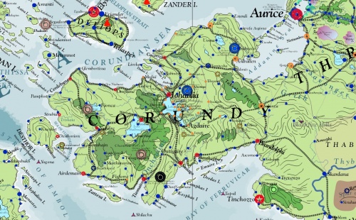
The terms Aracusia, Aracorundy today and Old Corundy formerly mean the western and southern portion of Corundy that have a strong prevalence of Arathracian culture due to the colonization during the Yophenthean Empire. The Arathracian Church, Nobility and Churchmen with Erechórebese Ancestry, and Yophenthean Law are predominant. These terms became necessary after the name 'Corundy' began to be applied to the entire peninsula in the Erechórebese Language. In other languages, different terms are often preferred. The name 'Kalama' is from Ithatian and means the pre-Gwenyan peninsula, especially under Vimalian Rule. The ancient Vimalians (Jathya-Dhumi) called the peninsula 'Kshandiguh'. 'Midretasso' refers to the peninsula under the rule of the Midretassene Empire.
Cultural Regions
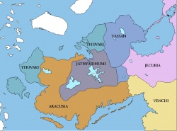
Corundy is divided into five cultural regions: Aracusia (also called Aracorundy), Jathya-Dhumi Highlands, Tassan Highlands, Thuvaki Coasts, and Venchi (Ferruvicar). Jathya-Dhumi is the most ancient and comprises the pre-Gwenyan civilizations that survived from ancient Kalama preserved today on the core plateau of the peninsula. The Thuvaki Coasts are two areas in the north and the northwestern islands that were colonized by the Pallathantic and later Ithatian tribes in antiquity. The Tassan Highlands are the core territory of the Midrinksi tribes that invaded eastern Corundy, conquered the peninsula, and then carved their own greater empire, Midretasso, that subsequently succumbed to the might of the Yophenthean Empire. Aracusia is the newest cultural element, introduced by the Yophentheans who colonized the west and southern coasts beginning with the conquest of Corundy in the middle of the sixth century (ca 550 AI), bringing their imperial code of ethics and the Arathracian Religion. The eastern periphery of the peninsula where it meets the Asdaurian Continent are culturally Jecubian and Ventish. The Thuvaki and Aracusian regions are principally Arathracian. The Jathya-Dhumi region worship the modern forms of the ancient Kalaman Gods.
History
Corundy is a peninsula that juts from the western edge of Asdauria into the sea. To the north is the Pallathantic Sea and to the south is the Memnosian Sea. The account of Aturyanda or the Aturyandakumi reports that over twelve thousand years ago, King Aturyanda of antediluvian Kathyasundi escaped the ravages of the Great Flood with his followers in the highlands of what is modern Corundy. After the waters receded, he gathered survivors and formed the seeds of the Great Flood Survivor Culture of Kalama. Millennia later, immigrating Midrinksi Tribes overtook the decaying Kalaman Civilization and built up Midretasso with its capital in Cetibrymio. During the centuries of the Midretassene Empire, the myth of the hero Addan (cf. Shalukka) and of the numinous god Vimal became steeped in hearts of the people. This empire expanded and conquered the Ithatian Islands and what is now modern-day Dúrandwor, but was in turn conquered by the Yophenthean Empire.
Kalaman Period
The Kalaman Period is the earliest and the longest period. It dates back to at least 6000 AS and according to legend to the Flood of Aturyanda. Due to its vast extent, it is properly divided into its own periods. Core components of Kalaman Civilization endure today in the cultures of the Vimalian Plateau and the Tassan Highlands in contrast to the Yophenthean-based civilization of southern and western Corundy. The ancient Kalaman name for the peninsula is Kshandiguh.
Midretassene Period
By the first part of the third century (ca. 215 AI), Uturnus has united the Midrinksi Tribes through wars and treaties into the early state of Midretasso. The Midretassene Empire achieved its greatest extent in the late fifth century to the early sixth century (ca 450 to 520 AI).
Midrinksi Conquest of Kalama
Yophenthean Period
Corundian Period
Often called the Corundian Period, the rule of the Yophenthean Successor State of Corundy is also the origin of the modern name Corundy.
Omandraline Empire of Sky
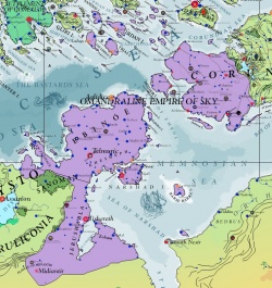
The Omandraline Empire of Sky ruled much of western Corundy in the late thirteenth century.
Golden Age of Sky
Middle Ages of Chaos
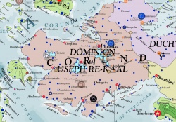
The Dominion of Useph-Re-Kaal lasted 1972 to 2037 AI.
Zantvika reigned as Queen of Johaulia and Vimalia from 2233 to 2267.
Isbajutha
Gorcorumbese Dominion
City-States
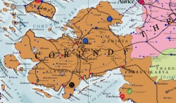
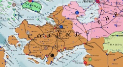
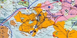
After Stalcast Bijäl and his powerful Duchy, later Grand Duchy along with the defiant military of Johaulia defeated the Gorcorumbese Empire in the Fifth Geddamin War, the cities and countries of Corundy found themselves liberated and reverted largely to local rule, with the exception of Zamiria in the east that remained a possession of Aurice due to the precedent of the Fourth Geddamin War. Aurice promised to recognize and defend the independence of Corundian states, all the while continuing in private to exert tremendous political and commercial influence over the peninsula. Corundy was ruled by several autonomous jurisdictions which did not form any central government until 2747 when the League of Corundy was formed. The League of Corundy is a supra-national organization that some see as a step towards federal unification of the peninsula.
League of Corundy
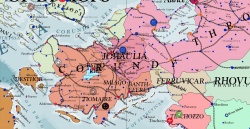
The League of Corundy is a supranational treaty organization established in 2747 to protect Corundy and facilitate trade and common economic interests among member states in the peninsula. The Noble Republic of Aurice most notably does not belong to the organization and the interests of the League are often counter to the imperial goals of the Aurician Empire.
Present Times
Eastern Corundy is subject to the Aurician Empire and the League of Corundy expresses the growing desire for solidarity and independence in the peninsula. According to advocates of the League, Aurice has refrained from gobbling up the states of Corundy so as not to appear tyrannical like Gorcorumb and prefers to manipulate rulers and people behind the scenes. Many detractors see Johaulia as a puppet-state of Aurice, though many Johaulians deeply resent statements to this effect.
Climate and Asdarography
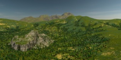
The climate of Corundy is warm, sometimes very warm in the summer until monsoons from the Memnosian Sea temper the heat in late summer. It is cool and rainy in the winter when cold storms of rain drift in from the north. Cypress trees, Stone Pines, olives, and vineyards dot the rural hills of Corundy. The Vimalian Plateau and the Tassan Plateau are famous for capturing great rainfall through the winter and early spring and in the late summer and early autumn. These highlands of Corundy are classified as mediterranean rainforests.
Corundian wines compete for prestige with those of Asbardy, Ithatia, Ebinóë, Throvy, and Glaye. Olive orchards produce oil shipped around the world. Riots of hills and small mountains flow from the south through the land to the north. Central Corundy is hilly plateau, held up by the Thugad and Damisatta Mountains. In this region sits Lake Vimala, the purview of the numinous god Vimal whose fame persists from ancient Kalaman times. Cities and towns reach along the coast of this deep lake that drains over great cataracts by the city of Johaulia into the Pallathantic Sea.
Lakes of Corundy
The peninsula is well watered and home to three sizable lakes, Lake Vimala, Lake Shallynaffe, and Lake Onoxa. These inland bodies of water are rich with folklore and considered divine by the Jathya-Dhumi people. Lake Vimala is the highest of these three lakes and rather deep. Since ancient times, each lake is thought to be inhabited and ruled by a powerful divinity who must be propitiated for safety and prosperity. The god of lake Vimala is Bhimala and the god of Shallynaffe is Shardan.
Fauna and Flora
Corundy is known for hilly woodlands, covered with Bimbhari and Jahshput trees. Gardens often have Tiskara and Muncha trees. Plants of the Vimalian and Tassan Plateaus are accustomed to abundant rains.
Some notable creatures of Corundy include: the spotted leopard, tree Lynx, hill sloth, forest boar, speckled bear, tree frog, forest goanna, turquoise salamander, rat, mouse, winged squirrel, magpie, finch, hawk, raven, rook, crow, blue-jay, cobra, snail, elven butterfly (known for its translucent green wings), chameleon, wood owl, badger, wolf, otter, bear, deer, beaver, squirrel, rabbit, hare, bee, grasshopper,
States
Corundian politics is informed by the liberation of Corundy from Gorcorumbese Rule in the very late twenty sixth century and by the historic division of Arathracians in southern and western Corundy who speak Corundian, a Yophenthean-based language, the Jathya-Dhumi people of central Corundy, the Shardanians and the Jaithans, and the Tassan people of the Tassan Highlands who speak Tassan and retain many cultural practices from ancient Midretasso, including the Kalaman Civilization that predates it.
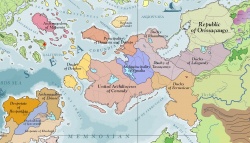
Corundy is not a single state. The Aurician Empire and the Republic of Johaulia are the two most preeminent political powers. The remaining peninsula is divided among twelve city-states.
Archpatriarchy of Airdemainy
Archpatriarchy of Numiria
Republic of Johaulia
The Republic of Johaulia on the Tassan Highlands and in the Valley of Lord Vimal is widely seen as the most prestigious state in Corundy. Johaulia is regarded as the cultural guardian of Midretassene and Kalaman civilizations. The city of Johaulia is sometimes viewed as the art capital of the Pallathantic. The name Johaulia can be used interchangeably for the capital city or the entire state of the Republic of Johaulia. There is a strong movement for the name of the Republic of Johaulia to be changed to the Republic of Vimalia to reflect better its Jaithan heritage.
Free Republic of Rhiony
Aurician Influence in Corundy
The two provinces of Zamir belong to the Aurician Empire. Aurice wields considerable influence among the states of Corundy due to its political size and economic influence. Aurice liberated Corundy from the Gorcorumbese Empire of the Ephysgæes as a consequence of the Fifth Geddamin War and gained much prestige in the peninsula. Aurice vowed to protect Corundy from encroachment of the Geddamin through the 27th century (2600's). The Empire of Magdala and the Republic of Ithatia have expressed discontent with Aurice's seeming economic domination of Corundy. Aurice uses its economic clout to benefit its trade in Corundy and to benefit Auricia corpora mercia. Ithatia sometimes calls for Aurice to respect the sovereignty of the city-states of Corundy. As Gorcorumb has continued its decline, the need for Aurician protection has become irrelevant in the eyes of some leaders.
The Republic of Johaulia in the Tassan Highlands holds much prestige and often functions in cooperation with Aurice in matters of foreign policy. This strengthens Aurice's hand and is seen by some as political compromise on the part of Johaulia. The Republic of Johaulia is widely viewed as an artistic haven and not well-founded for the nature of foreign policy. The Throvian language is related to the Tassan language giving some substance to a cultural tie.
Some Aurician magistrates called for a unified Corundy, but there was much disagreement until the the League of Corundy.
The Throvian is spoken widely in the coast towns and cities while Tassan is spoken in the hills and plateau. This area was historically under the rule of the Thracian Viceroy of Aurice during the late New Kalikán Empire.
Culturally, Zamiria is descended from ancient Midretasso. The Tassan Language comes from the ancient Midretassene Language which is related to the predecessor of the Throvian Language.
Zamirian Independence Movements
There have been several movements and attempts to bring the two provinces into greater autonomy or complete independence. Aurice does not require the locals to speak Throvian and all matters of local government are conducted in Tassan, except in some of the cities of the coast where Throvian is customary language. There is a growing independence movement for both provinces of Zamiria and a desire for membership in the League of Corundy.
Corundian Coast
The Corundian Coast is the western and southern portion of Corundy where the historic Corundian Language predominates and includes the city-states of Omflune, Estyo Rhe, Cerdebune, Strubia, Numire, Desthor, Airdemain, Tiomaire, Smiago, Bantheffrey, and Brandolphi. These city-states arose in the disorder that followed the defeat of Zantvika Queen of Johaulia in the Isbajath of the Penitents and the collapse of the rule of Prince Ulcanov of the Shattered Waters who was her liege lord. The cities became subject to the dominion of Medibgö and then the New Kalikán Empire in the 26th century (2500's). They are fiercely independent of each other and of Johaulia, but acknowledge Johaulia as a more neutral party than each other. Their citizens often label their rulers and magistrates as Pro-Aurician or Anti-Aurician, though in practice, few are purely either one. Aurician Corpora Mercia and financiers wield immense influence.
Languages of Corundy
Corundy is home to several languages and cultures, none of which is dominant. Jaithan and Corundian are the most prestigious. Shardanian, Tassan, Ithatian (Thuvaki), Throvian, and Ferruvicarese fill out the balance of spoken languages. In very times, there were many other languages related to Jathya-Dhumi that were spoken as well as the language of the solitary elves.
Economy
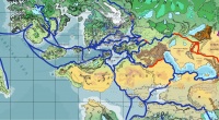
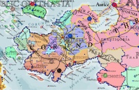
Corundy is well-placed for trade and commerce. Despite its rolling hills that may dampen land transport, its many vibrant sea ports have commerce with the nations of the Pallathantic-Memnosian Seas. Corundy is seated along with Throvy on the western end of the lucrative caravan routes through Asdauria to Sungo and elsewhere in the far east. The map of trade routes shown here uses blue for sea and river routes and red for land routes. Sky routes are reserved for light cargo with high commercial value as sky vessels, even modern titancraft air vessels, do not have the capacity to warrant the expense of common freight. The map shows the central importance of Corundy in Pallathantic Trade with the far east and Zephasia to the south. Dragonrail serves most of the coasts and traverses the continent from north to south with passenger and cargo transportation.
Corundy produces or provides world-famous wines, timber, fish, fine craft goods, textiles, masterful works of art, cheeses, grain crops, citrus fruit, among others.
Flags of the States of Corundy
The Archpatriarchy of Tiomairy has sixteen pointed Arathracian sun, depicted on a quartered field of blue and earth red, representing the the Arathracian Religion amid the fortunes of earth and sky. The Aurician Tricolor is flown in the two provinces of Zamiria which are subject to Aurice. The four-petaled golden flower of Johaulia rests on a berry-colored field and represents the aspirations of the Vimalian people of Johaulia.
Humanlikes
Humanlikes are very rare in Corundy compared to humans. Virtually all Gorcorumbese Giants who were not expelled after the Fifth Geddamin War left for fear of reprisals from the human populace. Uhlaks, Centaurs, Adamantine and Gorcorumbese giants, and halflings are seen as visitors, usually as tourists or conducting trade or diplomacy. During the Kalaman period, legends of elves inhabiting the western woodlands abounded. There have been no independently confirmed sightings of elves in the present and even legends say the elves disappeared many, many millennia ago. Other woodland creatures such as satyrs and nymphs continue to be reported by farmers and hunters, but remain on the outskirts of civilization and highly dubious. Gishaks and Quirth hold very small communities in the woods and in the wilder extents of the coastline.
Religions
The gods of the Jathya-Dhumi Pantheon are worshiped in Vimalia and in Rhiony, Arathracianism especially in the south and the west, and Incarnandism. Notable religious minorities include Paimbalans and Imzaami.
See Also
- Archpatriarchy of Tiomairy
- Asdauria
- Aurician Empire
- Free Republic of Rhiony
- Kalama
- Languages of Corundy
- League of Corundy
- List of the States of Corundy
- Midretasso
- Republic of Johaulia
- Tassan Highlands
- Vindalia
| This article is a stub. It requires further development by the creator. |
