Difference between revisions of "Memnosian Sea"
Trismegistus (talk | contribs) m (added Category:Atlas) |
Trismegistus (talk | contribs) m (→See Also) |
||
| (19 intermediate revisions by the same user not shown) | |||
| Line 1: | Line 1: | ||
| − | The Memnosian Sea rims the warm lands of northeastern Danona, northwestern Weshif, and southern Corundy. The Memnosian Sea teems with merchant vessels both on its surface and overhead in the air. Active trade routes join Asdauria to Danona. The Sultanate of Beph-Themesh and the Narsadese Republic are two great merchant nations in the Memnosian Sea. The waters of the sea are gentler than the Pallathantic and | + | [[File:MapLocatorMemnosianSea.jpg|thumb|200px|Locator Map of the Memnosian Sea]] |
| + | The Memnosian Sea rims the warm lands of northeastern [[Danona]], northwestern [[Weshif]], and southern [[Corundy]]. The Memnosian Sea teems with merchant vessels both on its surface and overhead in the air. Active trade routes join Asdauria to Danona. The [[Sultanate of Beph-Themesh]] and the [[Narsadese Republic]] are two great merchant nations in the Memnosian Sea. The waters of the sea are gentler than the [[Pallathantic Sea|Pallathantic]] and warmer. At times, storms from the north or dust storms from the desert can stir up the waters to the destruction of unwary sailors. The Memnosian Sea connects to the Pallathantic Sea via the [[Strait of Embol]] in the north and to the Sea of Malankhas to the south via the long [[Strait of Ummak]] to the south. For this reason, it is a critical navigable body in the west. Despite the dismantling of much of the [[Gorcorumbese Empire]], the colossal naval vessels of Gorcorumb can often be seen plying the waters about the coast of [[Ambrinqua]], especially in the [[Sea of Narshad]]. | ||
[[File:MemnosianSea 2750 001.jpg|thumb|300px|Map of the Memnosian Sea]] | [[File:MemnosianSea 2750 001.jpg|thumb|300px|Map of the Memnosian Sea]] | ||
| − | =Submerged Cities= | + | =Trade= |
| + | The Memnosian Sea is the critical link to the sea route between the [[Pallathantic Sea]] and the [[Strait of Ummak]] which enables access between the [[Pallathantic Region]] and nations of the such such as [[Oliblish]], [[Shagrela'al]], [[Omre]], [[Shanjahar]], and [[Benjalay]] with farther access through the [[Grand Canal of Benjalay]] to the [[Turtle Sea]], [[Za-Bahuna]], [[Kishira]], [[Opaz]], the [[Kawatti Pearling Islands]], [[Tangshan]], and [[Sungo]]. Important trade cities of the Memnosian Sea include [[Talil]], [[Syre]], [[Airdemain]], [[Tinchozzo]], [[Tiomaire]], [[Beh-Shelub]], [[Zamzafara]], and [[Bamuth-Nesir]]. Ancient Solmagali fishing techniques, sometimes amplified with modern [[titancraft]] are still practiced. The skyspace above the waters are important not only to Solmagali fishing, but also to sky trade routes and are the [[driftrange]] of the [[Jaibu]] cities of [[Shilachu]], [[Kaphia]], [[Tapsil]], [[Sorakha]], [[Yogona]], and [[Shahubuhin]]. | ||
| + | |||
| + | Freight includes fresh fish, timber and crafted goods from [[Corundy]] and [[Ambrinqua]], olive oil from northern [[Ambrinqua]] and [[Corundy]], textiles, Limestone and produce from [[Shelekhumbia]], marble from Ambrinqua, diamonds from the [[Adamantines]], sea salt from the salt flats of [[Corundy]], shipping craft, precious gems, and sadly antiquities, especially from [[Shelekhumbia]]. In ancient times, purple Narsadese dye, marble, and olive oil were important commodities. | ||
| + | |||
| + | =Antediluvian History= | ||
| + | {{See also|Sea of Memnosia}} | ||
| + | [[File:MapSeaofMemnosiaAntediluvian.jpg|left|thumb|150px|About 14,000 years ago before the [[Flood of Aturyanda]], the level of the Ancient Sea of Memnosia was higher than sea level and smaller in extent.]] | ||
| + | [[File:MapSeaofMemnosiaAndiluvianShorelineComparison.jpg|thumb|150px|Both ancient and modern shorelines shown for comparison]] | ||
| + | |||
| + | |||
| + | Earlier than 12,000 [[AS]] or nearly 15,000 years ago, the Ancient Sea of Memnosia was self-enclosed as earth changes associated with the [[Flood of Aturyahda]] had not yet caused it to overflow its northern bounds and connect with the [[Pallathantic Sea]]. These changes which causes sea level to rise worldwide reduced the size of what later became the islands of [[Narshad]] and [[Barse-Barra Island|Barse-Barra]]. Kalaman legend tells that the shores of the Ancient Sea of Memnosia were the homeland of the [[Jathya-Dhumi]] people. | ||
| + | |||
| + | ==Submerged Cities== | ||
| + | {{See also|List of Undersea Cities}} | ||
Legends report that the Great Flood swallowed many mythical cities off the former coast of the once smaller Memnosian Sea. Only merfolk and powerful wizards in times past had any chance of visiting these inhospitable places. Today there are rumors that rich adventurers wish to use titancraft submarines to explore these lost places that have not seen light for over seven thousand years. | Legends report that the Great Flood swallowed many mythical cities off the former coast of the once smaller Memnosian Sea. Only merfolk and powerful wizards in times past had any chance of visiting these inhospitable places. Today there are rumors that rich adventurers wish to use titancraft submarines to explore these lost places that have not seen light for over seven thousand years. | ||
| Line 9: | Line 24: | ||
=See Also= | =See Also= | ||
| + | <div style="column-count:3;-moz-column-count:3;-webkit-column-count:3"> | ||
*[[Ambrinqua]] | *[[Ambrinqua]] | ||
*[[Asdauria]] | *[[Asdauria]] | ||
| Line 17: | Line 33: | ||
*[[Gorcorumb]] | *[[Gorcorumb]] | ||
*[[Jerushabla]] | *[[Jerushabla]] | ||
| + | *[[Narshad]] | ||
*[[Narsadese Republic]] | *[[Narsadese Republic]] | ||
*[[Pallathantic Sea]] | *[[Pallathantic Sea]] | ||
*[[Sultanate of Beph-Themesh]] | *[[Sultanate of Beph-Themesh]] | ||
*[[Tinchozzo]] | *[[Tinchozzo]] | ||
| + | </div> | ||
{{List of Seas}} | {{List of Seas}} | ||
[[Category:Atlas]] | [[Category:Atlas]] | ||
| + | [[Category:Seas of Asdar]] | ||
{{stub}} | {{stub}} | ||
Latest revision as of 13:45, 20 January 2025
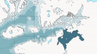
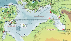
The Memnosian Sea rims the warm lands of northeastern Danona, northwestern Weshif, and southern Corundy. The Memnosian Sea teems with merchant vessels both on its surface and overhead in the air. Active trade routes join Asdauria to Danona. The Sultanate of Beph-Themesh and the Narsadese Republic are two great merchant nations in the Memnosian Sea. The waters of the sea are gentler than the Pallathantic and warmer. At times, storms from the north or dust storms from the desert can stir up the waters to the destruction of unwary sailors. The Memnosian Sea connects to the Pallathantic Sea via the Strait of Embol in the north and to the Sea of Malankhas to the south via the long Strait of Ummak to the south. For this reason, it is a critical navigable body in the west. Despite the dismantling of much of the Gorcorumbese Empire, the colossal naval vessels of Gorcorumb can often be seen plying the waters about the coast of Ambrinqua, especially in the Sea of Narshad.
Trade
The Memnosian Sea is the critical link to the sea route between the Pallathantic Sea and the Strait of Ummak which enables access between the Pallathantic Region and nations of the such such as Oliblish, Shagrela'al, Omre, Shanjahar, and Benjalay with farther access through the Grand Canal of Benjalay to the Turtle Sea, Za-Bahuna, Kishira, Opaz, the Kawatti Pearling Islands, Tangshan, and Sungo. Important trade cities of the Memnosian Sea include Talil, Syre, Airdemain, Tinchozzo, Tiomaire, Beh-Shelub, Zamzafara, and Bamuth-Nesir. Ancient Solmagali fishing techniques, sometimes amplified with modern titancraft are still practiced. The skyspace above the waters are important not only to Solmagali fishing, but also to sky trade routes and are the driftrange of the Jaibu cities of Shilachu, Kaphia, Tapsil, Sorakha, Yogona, and Shahubuhin.
Freight includes fresh fish, timber and crafted goods from Corundy and Ambrinqua, olive oil from northern Ambrinqua and Corundy, textiles, Limestone and produce from Shelekhumbia, marble from Ambrinqua, diamonds from the Adamantines, sea salt from the salt flats of Corundy, shipping craft, precious gems, and sadly antiquities, especially from Shelekhumbia. In ancient times, purple Narsadese dye, marble, and olive oil were important commodities.
Antediluvian History

Earlier than 12,000 AS or nearly 15,000 years ago, the Ancient Sea of Memnosia was self-enclosed as earth changes associated with the Flood of Aturyahda had not yet caused it to overflow its northern bounds and connect with the Pallathantic Sea. These changes which causes sea level to rise worldwide reduced the size of what later became the islands of Narshad and Barse-Barra. Kalaman legend tells that the shores of the Ancient Sea of Memnosia were the homeland of the Jathya-Dhumi people.
Submerged Cities
Legends report that the Great Flood swallowed many mythical cities off the former coast of the once smaller Memnosian Sea. Only merfolk and powerful wizards in times past had any chance of visiting these inhospitable places. Today there are rumors that rich adventurers wish to use titancraft submarines to explore these lost places that have not seen light for over seven thousand years.
Trade Routes of the Memnosian Sea
See Also
| This article is a stub. It requires further development by the creator. |


