Pytharnia


The southern land of the continent of Pytharniaca is usually called Pytharnia, leaving the scientific term 'Pytharniaca' to those who wish to refer strictly to the whole land mass. In its commonly used sense, Pytharnia refers to the southern half settled by humans. In origin, Pytharnia originally meant the hilly lands between the Mathgefrew Mountains of the south and the dense woodlands of the north. The core territory of the Empire of Magdala or 'The Magdalanate' rests on the Pytharnian Highlands. Scholars do not have a wide consensus on the origin of the name 'Pytharnia.' Some believe it originates from the name of ancient dragons. The ancient Jathya-Dhumi name for Pytharnia was 'Sayatha.'

Geographic Extent
Pytharnia in its broadest geographic sense as Pytharniaca is a subcontinent that has been slowly merging into the much greater continent of Asdauria for eons, forming the world-famous Jaggudorns, the highest mountains in the known world and probably the whole world. Riddled with ancient tribes and languages, Pytharnia is home to humans, elves, dwarves, halflings, gnomes, beastfolk, lizardfolk, trolls, and many more creatures. Nestled in the high foothills of the southwestern Jaggudorns are found four dwarven states. The Amandal Plateau is home to another dwarven state, Amandalia, where mystical dwarves have communed with the infinite for eternity. Sardeichs is the smallest and the most economically driven of these dwarven micro-empires. Although this smallest of the dwarven states is well in the Jaggudorns, its commerce and outlook is towards Pytharnia and the Pallathantic Sea.
Regions of Pytharnia
- Dúrandwor
- Ambrulia
- Durrhaunve
- High Pytharnia or Pytharnian Highlands (Magdala, Marshes of Baihu)
- Ithrad Mountains
- Gorrhevia
- Amosgire
- Rhevia
- Rhafindwor
- Esphagonia
- Gonfaloy (Landolin)
- Disdrire (South Disdrire or Lutramania, North Disdrire, West Disdrire)
- Agogia (Shadmaus)
- Lisgoria (Lake Lisgoria and surrounding lands)
- Dromblands
- Kasthavia
Northern Pytharnia

Northern Pytharnia, including central Pytharnia, is the realm of the Great Disdrire Forest. This ancient woodland had fended off the hands of civilization for centuries. The elves enjoy a kingdom here in the old growth woods and elsewhere swarthy Tuadbe human tribesmen range among great giant Redwoods and Sequoias along the northwest coast along with beastfolk.
Ithrad Mountains

Perched in a pocket of snow capped mountains, almost in the middle of the subcontinent is the dwarven Commonwealth of the Ithrads. This most progressive of dwarven states underwent revolution some time ago and transformed itself from a kingdom to a self-determining commonwealth. The statesmen of the Ithrads have worked cleverly to ensure that humans do not lastingly encroach upon the humanlikes of the Great Disdrire Forest.
Southern Pytharnia

Southern Pytharnia is in the main the domain of humans and their endless political schemes. Three great world powers hold dominion in the lower half of Pytharnia, the Aurician colonies of Agogia and the Shadevan, the Union of Pytharnia, and the Archduchy of Asbardy. The Sewdhaine War of the previous century (27th or 2600's) has tempered the taste for open warfare, but sees no rest to the imperial ambitions and subterfuge of the Pallathantic Nations.
Southeast Pytharnia

A stretch of land runs along the eastern coast, past the Shadevan Delta, separating the Bhinsasas or the southernmost mountains of the Jaggudorns from the Bay of Sealgo the northeasternmost tongue of the Pallathantic Sea. This stretch of land is Ambrulia, home of the centaur nation of Streionia. These centaurs are perhaps the most civilized in the world and were invited by the emperor of the Golden Empire of Pytharnia centuries ago into Ambrulia to settle and defend the land against the beast-men of Asdauria. Prior to the centaur habitation, common giants occupied this region.
The great Shadevan Delta, to the west of Streionia (Ambrulia) is the rich spoil of the Empire of Aurice. The mighty Shadew River opens its mouth to the north of this delta of islands as it drains into the Pallathantic Sea. For countless ages, five cataracts forbid seacraft from ascending higher on the Mighty Shadew River into the high plateau of the High Shadevan to the east of the Jaggudorn Mountains. The Grand Shadew Canal created by the Five Locks Project, spearheaded by a consortium of Aurician Corpora Mercia completed almost fifty years ago enables very large seabarges to circumvent the five cataracts in the Shadmaus enabling wares of the Pallathantic to be sold in Thrace and beyond and in return bringing great tonnages of grain from the High Shadevan to feed the great cities of the Pallathantic.

To the south of the continent of Pytharniaca stretches the Pallathantic Sea whose marine thoroughfare has united the merchants and adventurers of Pytharnia with dozens of other countries and climes.
Mathgefrew Mountains
The Mathgefrew Mountain Range lies east-west along the rise from the coastal lands of Dúrandwor to the higher elevation of High Pytharnia. The mountains are gently sloping compared to the Jaggudorns and do not rise more than 2100 meters above sea level.
Skynesses of Medibgö
Strangest of all are the skynesses of Medibgö. These flying islands of earth follow eight relatively perfect, concentric, circular orbits. The modern-day human inhabitants attribute the legendary defeat of the ancient giants who dwelt thereon to the supreme wizardry of the demi-mortal hero Meidb for which their nation is named. The existence of these highly magical islands of earth has been attested from very ancient times, pre-dating the Flood of Aturyanda. Titans are thought to have created them and their ongoing existence is strong circumstantial evidence for those who favor the titanist theory of human origins. The skynesses were occupied both before and after the flood by sky giants and their dominion of concentric sailing skynesses was called Aksiluva by the ancient Kalamans. With the Coming of the Neptultchi, their Dragon Knights gradually displaced many of the giant skynesses. In the centuries immediately preceding Salmakhamer, the demi-mortal hero Meidb led the ancient Kasthavians on skycraft to settle on the outermost skynesses. Despite their powerful dragon knights, the Neptultchi were no match for the demi-mortal and his wizard compatriots.
Marshes of Baihu
Between the Magdalanate and the Ithrad Mountains stretch the Marshes of Baihu, also considered part of the Pytharnian Highlands. Sparsely dotted with human settlements in its core, the marshes are home to lizardfolk and other beastfolk who have only loosely accepted the rule of the Empire of Magdala.
Amosgire Hills

To the southeast of the Ithrads and the southest of the Marshes of Baihu gently rise the mysterious Amosgire Hills which are widely understood to be haunted. The hills are largely infertile for intensive agriculture. The hills and their attendant valleys are riddled with sinkholes from collapsed limestone bedrock, exposing the waters beneath.
Dúrandwor
The midst of the south coasts of Pytharnia gently rise from the sea to the Mathgefrew Mountains. This old land is known as Dúrandwor and the spoken language Dúrandworese. The greater portion of Dúrandwor to the east is under the Kingdom of Thrain which is one of three states in the Union of Pytharnia. The western end of Dúrandwor as the mountains divide it from Gonfaloy is the Duchy of Ogentir, the largest single principality in the Empire of Magdala. Dúrandwor has been the home of Neptultchi and Moigthe tribes in ancient times, then colonized by the Midretassene Empire across the sea, then the Yophenthean Empire, and ruled over by the sky tribes in the middle ages.
Climate
The climate of Pytharnia varies from a mild temperate climate in the south and southwest to alpine in the northernmost reaches as it approaches Midrardia. Pytharnia receives most of its rainfall from storms arising in the Pallathantic or the Pytharnian Sea. The Jaggudorns block many arctic storms from striking Pytharnia from the northeast and it enjoys a milder winter for this reason. Pytharnia is humid even in the highlands where the large bodies of water always breathe some moisture into the air.
Snowfall
Along the south and southwest coasts, snow is very rare due to the moderating effects of relatively warmer sea breezes. Dúrandwor and southern Asbardy rarely receive snowfall, except in the mountains and high hills. Trevirs receives a light snow around Winter solstice and once again in the following month. The Tuadbean west coasts to the north very rarely receive snow due to the moderating effects of the sea. The high alpine valleys of Kasthavia and the Pytharnee Dromb Mountains, however, always receive snowfall in the winter. Pytharnia is prone to regular winter snowfall in the inland woods of the Great Disdrire Forest.
Chronology of Pytharnia
Pytharnia is thought to have been covered mostly by ice until the mythical dominion of the Titans. In the very ancient past, giants were the principal humanlike of the subcontinent.
Settlement of Pytharnia
The settlement of Pytharnia according to legends can be reduced to this sequence:
Dragons → elves → dwarves (gnomes) → titans → common giants (Kemerite Giants) → Neptultchi → Moigthe (halflings ?) → Colnorians, Thracians, Midretassenes
Languages of Pytharnia

A smattering of languages is spoken in southern Pytharnia, a region more densely populated than Corundy, Barathorn, or Lucacia. Humans are the most populous inhabitants, followed by dwarves. Isolates of giant tribes who speak a language distantly related to ancient Titanic can be found in the Shadevan and the Giant Isles off the coast of Asbardy. Uryala Gnomes, halflings, elves, lizardfolk, gishak, ogres, and Shadevan trolls are some of the other humanlikes with their own languages.
While no human language dominates, Medibgóëse has become a lingua franca, stemming from the time when the sorcerous skynesses of Medibgö helped to bring together the world after the revolutions of the Isbajutha in the 24th and 25th centuries (2300 to 2400's). The closely related Gonfalese Language is a mixture of Medibgóëse with many Ambrasian words. The Union of Pytharnia is particularly reliant on Medibgóëse as the official language of diplomacy between member states. The Empire of Magdala, the largest of the three members of the Union of Pytharnia, has no clearly dominant language in terms of numbers. The subjects of the Pytharnian Highlands speak Pytharnian. The sorcerers of Medibgö speak Medibgóëse. The subjects of the western principalities speak Gonfalese. The subjects of the Duchy of Ogentir in western Dúrandwor speak Dúrandworese. While the native speakers of Medibgóëse are the least populous, their tongue has the most cultural prestige. There are nearly equal amounts of native Gonfalese speakers and native Asbardian speakers in the Asbardian province of Flisbardy, lodged between the areas of the Asbardian Language and the Gonfalese Language on the map. Tuadbe is the language of northwestern forests and spoken by many of the beastfolk as well.
Government and Politics

Three great powers struggle for leadership of southern Pytharnia. To the east rests the Archduchy of Asbardy which swallowed up its neighbors Priordania and Graith during the Sewdhaine War. The Archduchy's political machinations brought about the partition of Gonfaloy as well. The sprawling Empire of Magdala is a patchwork quilt of principalities and chartered cities owing fealty to the Emperor. The Empire of Magdala is in turn part of the Union of Pytharnia that grew out of the alliance to defeat the New Kalikán Empire in the 26th century (2500's) in a tangled network of obligations and treaties that could muddle the wits of the sharpest political philosopher. The Union of Pytharnia is an alliance of the Empire of Magdala, The Empire of Medibgö, and the Kingdom of Thrain. Medibgö is a union of floating skynesses under the rule of the Medibgóëse Emperor. Although they are not numerous in folk or lands, they are powerful sorcerers and have meddled in the affairs of the surface of Pytharnia for centuries. The country of Gonfaloy, now divided, was settled and colonized by ancient Medibgösk sorcerer-warriors. The two Gonfaloys and Ambrasia along with the Commonwealth of the Ithrads to the north form an unbroken line of states not openly aligned to either Asbardy or Magdala. The rulers of these four states, to ensure their continued independence, have played the ambitions of Magdala against Asbardy.
Flags of States and Principalities of Pytharnia
This gallery includes dwarven micro-states of the southwestern Jaggudorns as they are politically considered part of Pytharnia.
Flags of States of Pytharnia

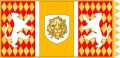
Flag of the Noble Republic of Aurice
Flag of the Kingdom of Dagdoria

Flag of the Commonwealth of Gdelisica
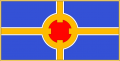
Empire of Magdala, Imperial
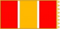
Empire of Magdala, Civilian
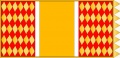
Empire of Magdala, Military
Empire of Medibgö, Civilian
Empire of Medibgö, Military


Flags of Subject Dominions of Pytharnia

Imperial Province of the Magdalanate


See Also
- Bhinsasa Mountains
- Bryndyd
- Creatures of Pytharnia
- Great Disdrire Forest
- History of Pytharnia
- Ithrad Mountains
- Jaggudorn Mountains
- Languages of Pytharnia
- Mathgefrew Mountains
- Pallathantic Sea
- Pytharnee Dromb Mountains
- Trevirs
| This article is a stub. It requires further development by the creator. |