Difference between revisions of "Pallathantic Sea"
Trismegistus (talk | contribs) m (add image) |
Trismegistus (talk | contribs) m (add locator map) |
||
| Line 1: | Line 1: | ||
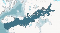
| + | [[File:MapLocatorPallathanticSea.jpg|thumb|200px|Locator Map of the Pallathantic Sea]] | ||
| + | |||
{{Hatnote|"Pallathantic", "Pallathantic Coast", "Pallathantic Rift", and "Pallathantic Basin" redirect here. For other uses, see [[Pallathantic (disambiguation)]], [[Pallathantic Rift (disambiguation)]], [[Pallathantic Basin (disambiguation)]], and [[Pallathantic Coast (disambiguation)]].}} | {{Hatnote|"Pallathantic", "Pallathantic Coast", "Pallathantic Rift", and "Pallathantic Basin" redirect here. For other uses, see [[Pallathantic (disambiguation)]], [[Pallathantic Rift (disambiguation)]], [[Pallathantic Basin (disambiguation)]], and [[Pallathantic Coast (disambiguation)]].}} | ||
Revision as of 12:32, 8 January 2014
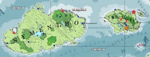
The fame of the Pallathantic Sea has given its name to the region and the lands which its waves wash. The goddess Pallatha is the sea's namesake and she is credited with guiding the ancient Pallathantic Tribes to settle its islands thousands of years ago. The Pallathantic Sea is formed between the subcontinent of Pytharnia to the north and the minor continent of Danona and the lands of Throvy and Corundy to the south. There are over a hundred islands in the Pallathantic Sea, the greatest of which are Nymentho and Erechóreb. The sea has a great moderating effect on the lands and islands that touch it and magdeologers believe that the sea is the means by which warm water from near the equator is brought north. The commercial and cultural worth of the Pallahthantic Sea is incalculable to the surrounding nations and peoples.
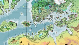
Geographic Extent
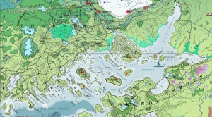
The sea traffic of the Pallathantic is immense and its commercial value cannot be overstated. By means of the sail and the oar, the Pallathantic Sea joins western Asdauria to Pytharnia, Pytharnia to Corundy, Ambrinqua to Pytharnia. The sea communicates with the Pytharnian Sea to the north and the Memnosian Sea to the south. The Pallathantic Sea affords access to the Mathareusan Sea to the west. For this reason, this Sea has been fought over for centuries. The modern nations of the Pallathantic observe treaties to ensure the fair use of its waterways and resources. Sea piracy is uncommon in the eastern Pallathantic and there are few finer ways of taking a holiday than touring the many coast cities and towns of the Pallathantic by yacht.
The western Pallathantic is the home of Nymentho and Erechóreb. Its waters are deeper and can become quite choppy in inclement weather. Sea Piracy though rare today is not unknown here, especially from the coves and inlets of northern Danona. Despite these dangers, many great ships ply its waters with trade and passengers. The Bastards Sea is so named in recognition of historic piracy once rampant in its waters.
Shadevan Delta
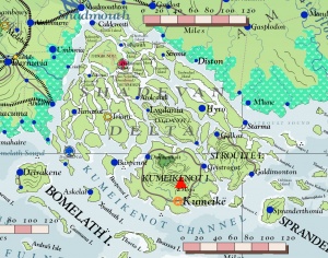
The Shadevan Delta is an important place of passage between the Pallathantic Sea and the mouth of the Shadew River. The Five Locks of the Shadmaus enable great sea barges to pass from the sea up through the Shadew River into the High Shadevan Valley, including Thrace and Ardobha. The abundant waters of the Shadew River enter the eastern Pallathantic Sea and affect the circulation of currents. For this reason, the currents by the islands of the Shadevan Delta move away from the mouth of the Shadew River, flowing strongly to the south.
Islands of the Pallathantic Sea
There are numerous little seas in the Pallathantic Sea: the Yophenthean Sea, the Golden Sea, the Giants Sea, the Siulian Sea, the Sea of the Dead, the Bastards Sea, the Fecund Sea, the Sea of Asbardy, the Maturnian Sea, the Corundian Sea, the Sea of Forgetfulness, Asgion's Sea, the Addanine Sea, the Sea of Magdaia, the Gonfalese Sea, and the Bay of Sealgo.
The greatest islands of the Pallathantic are, in order, Nymentho, Erechóreb, Deliops, Maturn, Kumeikënot, Gliri, Desthor, Stroultë, and Zander.
Golden Isles
Nymentho and Erechóreb, the two greatest isles of the Pallathantic Sea, were called the 'Golden Isles' after their settlement by the Yophentheans were also known as the 'Goldenlings' in ancient times. The Golden Isles are historically Arathracian in religion and the spoken language of humans is Erechórebese and Nymenthonese, both derived from ancient Classical Yophenthean.
Trade Routes of the Pallathantic
The Pallathantic Sea is a vital sea route for merchants, navies, and the flow of voyagers between Pytharnia, the Ithatian Isles, Erserce, Throvy, Corundy, Ambrinqua, the Memnosian Sea, the Wild Coast of Danona, Erechóreb, Nymentho, the Pytharnian Sea, and the Mathareusan Sea. The east to west orientation of the Pallathantic Sea and its relative narrowness create an ideal highway of water for transportation. All countries with a significant stretch of coast along the Pallathantic are involved with sea commerce, including Thrain, Ithatia, Johaulia, Aurice, Pastravia, Ogentir, Asbardy, Erechóreb, Gorcorumb, Desthor, Siul, Thrysto, Gliri, and Xsys.
Historic Sea Merchants
Historically, the Xsytes and the Narshadites have been great merchants of the Pallathantic. Narshadites voyages in coast-hugging barges and caravels. The seas were typically calmer along the coast and afforded easy access to the shore and to commercial ports, making travel in the open sea often unnecessary. The Xsytes developed and perfected the skybarge, a large, squat vessel with relatively high tonnage compared to other historic skycraft and a low altitude of flight, typically voyaging at an altitude of one dwarven fathom or less (160m) above the surface of the earth or the sea. The openness of the sea ensured that Xsyte merchants did not need to negotiate or contend for rights of passage above the dominion of unfriendly rulers. Ithatians, Midtretassenes, Dúrandworese, Ersercese, and Ebinóëse have also depended upon sea commerce for a living.
Five Locks
The completion of the Five Locks Project has opened up the interior of the High Shadevan Plateau by means of the great Shadew River and has increased the importance of sea trade in the east Pallathantic. The Five Locks have enabled Thracian farmers and gontha herders to prosper. All manner of trade goods from the Pallathantic can now be shipped by the Shadew River to Thrace and Ardobha.
Creatures of the Pallathantic Sea
The relatively shallowness of the eastern Pallathantic Sea and the immense coastal length both on the mainland and the flotilla of islands in the sea provide a multitude of estuaries, harbors, and shoals for life to propagate and flourish. The Tisponios Reef is famous for its peculiar coral. Organchan Voraxes are not uncommon to see in the waters of the Kumeikenot Channel. They are as great as large whales, but more memorable to humans as they frequent shallow coasts for food. Dolphins, small sharks, porpoises, and small whales are commoner away from the coasts. Seals were plentiful in ancient times in many places, but due to overhunting, are now limited to the Wild Coast.
Marine life eaten by humans and other humanlikes includes shrimp, squid, octopus, anchovy, mackerel, swordfish, sole, lobster, cuttlefish, red snapper, Pallathantic bass, and cod.
Indigenous Humanlikes of the Pallathantic Sea
Several humanlike races made their homes in the littoral and sea mounts of the Pallathantic Sea. Merfolk and Tritons are the most commonly met as they have dealings with humans. Axmandel tribes have colonies through the Wild Coast of Danona. Brine-loving Gishak have some colonies in the Shadevan Delta and along the southwest coast of Erserce. Ithrabbi of ancient Neptultchi provenance once dwelt in the Sea of Asbardy, but were eliminated during the Yophenthean Empire. Ithrabbi colonies elsewhere in the Pallathantic remain disputed and the extent of the sea ensures that their absence can be at best unconfirmed.
Merfolk
The merfolk are inseparable with the Pallathantic Sea. They can voyage both above and below the surface, preferring the surface for ease of movement. In ancient times, it was common to make an offering of small gold coins when voyaging above the waters of Siul to ensure safe passage without mischief.
The merfolk have several undersea cities in the central to western Pallathantic Sea. The greatest of these is Siul, ruled by the goddess Dáwan and her coterie of mermen. Naquir and Geddi are also very populous and important. These cities rest on high sea mounts or in the case of Geddi, on the continental shelf of Danona.
Tritons
Thought to be related to the Merfolk, the Tritons are another aquatic humanlike race that that occupy the eastern Pallathantic.
Politics
The Pallathantic Sea is probably the most heavily voyaged sea in the world of Asdarah with the exception of the Sungotine Sea.
See Also
What follows is an incomplete listing of islands in the Pallathantic Sea. The first ten are intended to be in order of surface area.
| Name | Image | Country | Population | Capital or Chief City | |
|---|---|---|---|---|---|
| 1 | Nymentho | [[File:|100px]] | [[File:|100px]] | 1,107,000 | Ophia, Selexis |
| 2 | Erechóreb | [[File:|100px]] | [[File:|100px]] | x | Rhafyx, Yophénthë |
| 3 | Deliops | [[File:|100px]] | [[File:|100px]] | x | Elystrio |
| 4 | Kumeikenot | [[File:|100px]] | [[File:|100px]] | x | Kumeikë |
| 5 | Maturn | [[File:|100px]] | [[File:|100px]] | x | Gnousikai |
| 6 | Gliri | [[File:|100px]] | [[File:|100px]] | x | Istokkos |
| 7 | Zander | [[File:|100px]] | [[File:|100px]] | x | Bardi |
| 8 | Desthor | [[File:|100px]] | [[File:|100px]] | x | Desthorion |
| 9 | Stroultë | [[File:|100px]] | [[File:|100px]] | x | Galdimonton |
| 10 | Ganter | [[File:|100px]] | [[File:|100px]] | x | Gantron |
| # | Bryso | [[File:|100px]] | [[File:|100px]] | x | City |
| # | Oppor | [[File:|100px]] | [[File:|100px]] | x | City |
| # | Gallisto | [[File:|100px]] | [[File:|100px]] | x | City |
| # | Lygdanot | [[File:|100px]] | [[File:|100px]] | x | Lygdania |
| # | Imomólë | [[File:|100px]] | [[File:|100px]] | x | Magdë |
| # | Erethrob | [[File:|100px]] | [[File:|100px]] | x | Chmias |
| # | Irdan | [[File:|100px]] | [[File:|100px]] | x | Kadonteia |
| # | Trias | [[File:|100px]] | [[File:|100px]] | x | Xambë |
| # | Thulidnot | [[File:|100px]] | [[File:|100px]] | x | Iadogos |
| # | Bomelath | [[File:|100px]] | [[File:|100px]] | x | Deirakene |
| # | Amelkas | [[File:|100px]] | [[File:|100px]] | x | Amirte |
| # | Ardné | [[File:|100px]] | [[File:|100px]] | x | Zeptril |
| # | Sandisi | [[File:|100px]] | [[File:|100px]] | x | Neskor |
| # | Sprander | [[File:|100px]] | [[File:|100px]] | x | Spranderthonia |
| # | Sigully | [[File:|100px]] | [[File:|100px]] | x | Steke |
| # | Fese | [[File:|100px]] | [[File:|100px]] | x | Ismew |
| # | Psulinth | [[File:|100px]] | [[File:|100px]] | x | City |
| # | Kepher | [[File:|100px]] | [[File:|100px]] | x | City |
| # | Sulmatta | [[File:|100px]] | [[File:|100px]] | x | City |
| # | Kelkoth | [[File:|100px]] | [[File:|100px]] | x | Menctuthir |
| # | Three | [[File:|100px]] | [[File:|100px]] | x | Thamocray |
| # | Thisgrundi | [[File:|100px]] | [[File:|100px]] | x | City |
| # | Umbylot | [[File:|100px]] | [[File:|100px]] | x | Sondraver |
| # | Pheden | [[File:|100px]] | [[File:|100px]] | x | City |
| # | Firrafferse | [[File:|100px]] | [[File:|100px]] | x | City |
| # | Camprotrude | [[File:|100px]] | [[File:|100px]] | x | City |
| # | Thistro | [[File:|100px]] | [[File:|100px]] | x | City |
| # | Pheidannokite | [[File:|100px]] | [[File:|100px]] | x | City |
| # | Island | [[File:|100px]] | [[File:|100px]] | x | City |
| This article is a stub. It requires further development by the creator. |
| Antarctica | Asdauria | Barathorn and Orrhymby | Danona | Pallathantic Sea | Pytharnia | Sungo | Two Bahunas |
|---|---|---|---|---|---|---|---|
|
Deepearth
|
|
Major Isles
Major Isles Minor Isles |
Deepearth |
